


PHR TM Day 38

ARVIEU
User

Length
17 km

Max alt
2041 m

Uphill gradient
252 m
Km-Effort
22 km

Min alt
1579 m

Downhill gradient
683 m
Boucle
No
Creation date :
2021-02-22 14:20:49.242
Updated on :
2021-02-22 14:21:49.117
4h56
Difficulty : Very difficult

FREE GPS app for hiking
 SityTrail
IGN / Geographical institutes
SityTrail Plus
The world is yours!
About
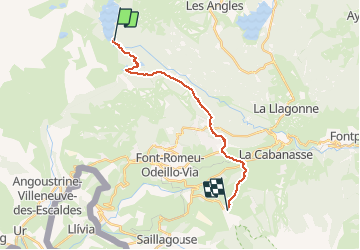
Trail Walking of 17 km to be discovered at Occitania, Pyrénées-Orientales, Les Angles. This trail is proposed by ARVIEU.
Positioning
Country:
France
Region :
Occitania
Department/Province :
Pyrénées-Orientales
Municipality :
Les Angles
Location:
Unknown
Start:(Dec)
Start:(UTM)
418219 ; 4712429 (31T) N.
Comments